Border
With this class you can select one or more region on the surface of the Earth. In every instance of Border you can choose whether the specific region is excluded from the overall result with the switch exclude. To determine whether a specific point will be used furthermore the following algorithm will be applied: In a first step all points are selected if first border excludes points otherwise all points excluded. When every point will be tested for each instance of border from top to bottom. If the point is not in the selected region nothing happens. Otherwise it will included or excluded depending on the switch exclude.
First Example: The border excludes all continental areas. The result are points on the oceans only.
Second Example: First border describes the continent north america. The next borders excludes the great lakes and the last border describes Washington island. In this configuration points are selected if they are inside north america but not in the area of the great lakes. But if the point is on Washington island it will be included again.
Rectangle
The region is restricted along lines of geographical coordinates. minPhi and maxPhi describe the lower and the upper bound of the region. minLambda and maxLambda define the left and right bound.
| Name | Type | Annotation |
|---|---|---|
minLambda | angle | |
maxLambda | angle | |
minPhi | angle | |
maxPhi | angle | |
exclude | boolean | dismiss points inside |
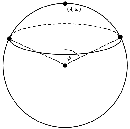
Cap
The region is defined by a spherical cap with the center given in geographical coordinates longitude (lambdaCenter) and latitude (phiCenter). The radius of the cap is given as aperture angle psi.
| Name | Type | Annotation |
|---|---|---|
lambdaCenter | angle | longitude of the center of the cap |
phiCenter | angle | latitude of the center of the cap |
psi | angle | aperture angle (radius) |
exclude | boolean | dismiss points inside |
Polygon
The region is defined by inputfilePolygon containing one or more polygons given in longitude and latitude. An additional buffer around the polygon can be defined. Use a negative value to shrink the polygon area.
| Name | Type | Annotation |
|---|---|---|
inputfilePolygon | filename | |
buffer | double | buffer around polygon [km], <0: inside |
exclude | boolean | dismiss points inside |